Reinhold Messner (right) looking at Ötzi after more ice had melted or been hacked away.
Ötzi the iceman is the holy grail of glacial archaeology, nothing less. The discovery of the 5300-year-old mummified body and the associated artefacts created a media frenzy and great public interest. Today, 250000 people visit the Ötzi Museum in Bolzano each year to get a glimpse of Ötzi and the exhibited artefacts. A wealth of scientific papers, popular books and documentaries have been published.
Ötzi was discovered in 1991 in a gully at the Tisenjoch pass close to the Italian/Austrian border. The original interpretation by the Innsbruck-based archaeologist Konrad Spindler was that Ötzi froze to death in the gully. He was quickly covered by a glacier and remained encased in ice until he melted out in 1991. How else could the body and artefacts be so well preserved?
Paper by Mary Valante given at the Fourth Annual Appalachian Spring Conference in World History and Economics (2009).
Viking raiders first appeared on the shores of western Europe in the 790s. For the year 793 the Anglo-Saxon Chronicles record, “…terrible portents appeared…and fiery dragons were seen flying in the air…. and the harrying of the heathen miserably destroyed God’s church at Lindisfarne.”, while the Annals of Ulster for 795 describe, “The burning of Rechru by the heathens, and Scí was overwhelmed and laid waste.” These early raids followed a distinct pattern – one or two ships, coastal raids , and hit-and-run tactics. But in the 830s and 840s, the patterns of raids changed suddenly and dramatically.
In Ireland, the Annals of Ulster record for the year 837 “A naval force of the Norsemen sixty ships strong was on the Bóinn, [and] another one of sixty ships on the river Life. These two forces plundered the plain of Life and the plain of Brega, including churches, forts and dwellings. The men of Brega routed the foreigners at Deoninne in Mugdorna of Brega, and six score of the Norsemen fell.” According to the Anglo-Saxon Chronicle, in 838 “In this year came a great pirate host to Cornwall…”
The switch to larger raiding parties was swiftly followed by settlement, as in 841 Vikings first set up camp at Dublin. By the middle of the ninth century, it is clear that changes back in Scandinavia were having a direct impact on events in the British Isles, as shown by a takeover at Dublin in the 850s, and the arrival of the “Great Heathen Army” in Anglo-Saxon England in the 860s.
Some scholars have argued that the early raids were a deliberate “softening up” of Europe, a deliberate prelude to land-grabbing. But this view assumes that raiders were displaced farmers, victims of climate change or population pressures. I would argue instead that the earliest raids were the work of minor chieftains, stealing goods to trade at the new market towns in Norway and Denmark. The large-scale raids from the 830s onwards were the result of the success of the early raids, which allowed the market towns to become well-established and successful.
This in turn had provided funds for kings in Norway and Denmark to establish themselves more firmly, organize much larger raids, and then quickly to the deliberate founding or capture and settlement of new market towns in Ireland and Anglo-Saxon England. After the 850s, competition for power within Denmark and Norway, partially represented by vying for control of these same early towns, led once again to changes in Viking activities as seen especially in Ireland and England.
The earliest raiders targeted monasteries, relatively wealthy and usually undefended sites. People and portable valuables were their targets, “Howth was plundered by the heathens, [and] they carried off a great number of women into captivity” and “The heathens plundered Bennchor at Airtiu(?), and destroyed the oratory, and shook the relics of Comgall from their shrine.” The shrine, not the relics, held value the raiders could understand. Based on excavations of longships, a raiding crew would have consisted of about 30 men, led by their chieftain after planting and before harvest season.
A series of Earth-shattering volcanic eruptions in Iceland during the Middle Ages may have spurred the people living there to turn away from their pagan gods and convert to Christianity, a new study finds.
The discovery came about thanks to precise dating of the volcanic eruptions, which spewed lava about two generations before the Icelandic people changed religions.
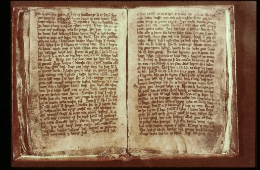
Codex Regius
But why would volcanic eruptions turn people toward monotheism? The answer has to do with the “Vǫluspá,” a prominent medieval poem that predicted a fiery eruption would help lead to the downfall of the pagan gods, the researchers said.
Historians have long known that the Vikings and Celts settled Iceland in about A.D. 874, but they were less certain about the date of the Eldgjá lava flood, the largest eruption to hit Iceland in the past few millennia. Knowing this date is crucial, because it can tell scientists whether the eruption — a colossal event that unleashed about 4.8 cubic miles (20 cubic kilometers) of lava onto Greenland — impacted the settlement there, the researchers said.
To investigate, the researchers examined ice core records. Their results showed that the eruption took place less than 100 years after people settled the island. The volcano began gushing lava in the spring of A.D. 939 and lasted, at least episodically, until the autumn of 940, the researchers said.
a) Locations of Eldgjá, the NEEM drill site and medieval documentary evidence referenced in the text covering 939–942 CE. b) Section of the 75-km-long Eldgjá eruption fissure at Ófærufoss. c) The Codex Regius; finger points to beginning of stanza 57 of Vǫluspá
“This places the eruption squarely within the experience of the first two or three generations of Iceland’s settlers,” study lead researcher Clive Oppenheimer, a professor of volcanology at the University of Cambridge, in England, said in a statement. “Some of the first wave of migrants to Iceland, brought over as children, may well have witnessed the eruption.”
The finding matches medieval chronicles from Ireland, Germany and Italy that noted the spread of a haze in 939. Moreover, the tree-ring data revealed that in A.D. 940, the Northern Hemisphere had one of its coldest summers in the previous 1,500 years — a cold shift consistent with the release of large amounts of volcanic sulfur into the atmosphere, the researchers said.
“In 940, summer cooling was most pronounced in Central Europe, Scandinavia, the Canadian Rockies, Alaska and Central Asia, with summer average temperatures 2 degrees Celsius [3.6 degrees Fahrenheit] lower,” co-researcher Markus Stoffel, a professor in the Department of Earth Sciences at the University of Geneva in Switzerland, said in the statement.
Suffering followed, with hard winters and drought in the spring and summer. Locusts invaded, and livestock died. “Famine did not set in everywhere, but in the early 940s, we read of starvation and vast mortality in parts of Germany, Iraq and China,” said study co-researcher Tim Newfield, an environmental historian at Georgetown University, in Washington, D.C.
However, no texts from that period survive from Iceland, the volcano’s homeland.
A mere two generations after the Eldgjá eruption, in about A.D. 1000, the people of Iceland formally converted to Christianity. And it likely had to do with the “Vǫluspá,” the researchers said.
The “Vǫluspá” was written after the eruptions, in about A.D. 961. It describes how an eruption and meteorological events would mark the end of the pagan gods, who would be replaced by one, singular god, the researchers said.
Part of the poem explains how “the sun starts to turn black, land sinks into sea; the bright stars scatter from the sky … flame flies high against heaven itself,” according to a translation.
Considering Eldgjá’s eruptions date to before the poem was written, Icelanders who experienced the fiery spectacle likely looked back at the events and wrote the poem, “with the purpose of stimulating Iceland’s Christianization over the latter half of the 10th century,” the researchers wrote in the study, published online in the journal Climate Change.
Scientists have found evidence that the medieval taste for the beautiful fine fur of red squirrels, traded with Viking Scandinavia, may have been a factor in the spread of leprosy.
The link between human and animal leprosy had already been suggested when the disease was found in modern squirrels in the UK, but the new evidence is from analysis of the skull of a woman who died more than 1,000 years ago in Suffolk, before the Norman invasion.
She suffered from the same strain of leprosy as other medieval skeletons from along the East Anglian coast, and from skeletons of the period from Denmark and Sweden – and closely related to the type of leprosy still found in modern red squirrels.
The disease was one of the most dreaded of medieval times, with many victims shunned and forced to live apart from society. The unfortunate woman – whose remains were found by chance in a garden in Hoxne in the late 20th century and are now in the collection of the museum in Diss – had disfiguring marks to the skull including the destruction of her nose, hallmarks of leprosy. The damage was so severe it suggests the disease would have had terrible effects on her life, leaving her with extensive facial lesions and probably nerve damage to her hands and feet.
Radiocarbon dating suggests that she lived between 885-1015AD, and analysis of the bacteria showed she had the same strain of leprosy as a man from Great Chesterford who lived centuries earlier. Inskip said the skeletal analysis, together with the prevalence of leper hospitals in East Anglia from the 11th century on, suggested the disease was endemic in the region for centuries, earlier than in other parts of the country. Inskip said the same chalky soil giving good bone preservation is found in other areas including Hampshire and Dorset, but no cases of leprosy have been found in early Anglo-Saxon cemeteries there.
The authors suggest that North Sea trade links with Scandinavia may explain the prevalence of the disease in East Anglia.
Inskip, who said it was notable that squirrels were sometimes kept as pets, said: “It is possible that this strain of leprosy was proliferated in the South East of England by contact with highly prized squirrel pelt and meat, which was traded by the Vikings at the time this woman was alive. Strong trade connections with Denmark and Sweden were in full flow in the medieval period, with King’s Lynn and Yarmouth becoming significant ports for fur imports.”
The last case of human leprosy in the British Isles was more than 200 years ago, but a recent study has demonstrated leprosy infection in red squirrels, now an endangered species, in once of their last UK strongholds, on Brownsea Island in Dorset. Red squirrels in Scotland have also been found to carry a different strain of leprosy. It affects the animals as it does humans, leaving them with lesions on their muzzles, ears and paws.
The strain in the squirrels is the same as one found in the nine-banded armadillo, which has been linked to some cases of human leprosy in Florida.
Wow! It’s V.S.L.M.’s anniversary in the blogging world today. It has survived for a whole decade it seems. 🙂 Let’s see if we can do one more! A big thank you to all the visitors and supporters over the years.
Perhaps it’s time to do another site re-design. While this one has worked just fine, I think I might’ve just gotten a bit tired of it. I’ll be on the look out for something new in the coming weeks.
Eighty skeletons found shackled in a mass grave near Athens last year could be the remains of Cylon’s followers. The Athenian nobleman was the first recorded winner of the Olympic Games, but he went down in history for attempting to take over the city by force and become its only leader, some 2,600 years ago.
The skeletal remains were discovered in the Falyron Delta Necropolis – a large cemetery dating back to the 8th to 5th century BCE that was unearthed over a century ago during the construction of an opera house and a library south of Athens.
The wrists of the 80 individuals had been clamped by iron shackles. They were put in the mass grave but arranged in an orderly manner, which suggests they were not slaves.
They appear to have been the victims of a bloody execution. Archaeologists determined that they had died from blows to the head sometime between 675 and 650 BCE, as dated by the analyses of pottery fragments recovered from the grave. This was a time of great social unrest in Ancient Greece.
Discovering so many ancient skeletons in one place is rare, so the researchers were intrigued and wanted to find out who these individuals had been and why they were killed. Ever since the skeletons were unearthed, the most popular hypothesis discussed by archaeologists has been that these individuals were part of Cylon’s army that tried to take over the city.
What is certain is that the coup attempt failed. Cylon was defeated but managed to escape and hide in a temple. The men who fought for him were not so lucky, and just like the individuals in the mass grave, they were executed.
Archaeologists have started using innovative scientific techniques worthy of a CSI episode to learn more about what happened and to see if they can get clues to confirm this theory.
The tests conducted on the skeletons include DNA profiling as well as radiographic and isotopic analyses to shed light on these people’s age, geographic origin and social status. The archaeologists might also get an idea of whether these men were related and whether they were in good health overall.
All this information could help confirm whether these men were likely to have been Cylon’s supporters. Preliminary results back up the idea that these were Cylon’s men, as they appear to have been young and healthy when they died, as would be expected of fighters in an army. However, more investigations will be needed before the full picture can emerge – the DNA analyses in particular are awaited with impatience to establish the relationships between these people who were executed together in such a violent manner.


You must be logged in to post a comment.